• Home
  • 3D Scanning
    • BLK360
    • BLK360 G1
    • BLK2GO
    • BLK2GO PULSE
    • BLK2FLY
    • BLKARC
    • RTC360
    • P-Series
    • Cyclone FIELD 360
    • Cyclone REGISTER 360 PLUS
    • CloudWorx
    • Cyclone 3DR
    • TruView
    • Map360
    • Archive
  • Mobile Mapping
    • Hardware
      • Pegasus Backpack
      • Pegasus Two Ultimate
    • Software
      • Inertial Explorer
      • Infinity
      • Pegasus Manager
        • Mission Planning
        • Processing
        • Rail Factory
        • Rail Track Geometry
        • Real Time Data Exchange
        • Road Factory
        • Trajectory Adjustment
        • View Only
      • Pegasus MDA
  • Virtual Training
SMART PLAN
Login Register
Table of Contents
Toggle sidebar & navigation
  • Home
  • 3D Scanning
    • BLK360
    • BLK360 G1
    • BLK2GO
    • BLK2GO PULSE
    • BLK2FLY
    • BLKARC
    • RTC360
    • P-Series
    • Cyclone FIELD 360
    • Cyclone REGISTER 360 PLUS
    • CloudWorx
    • Cyclone 3DR
    • TruView
    • Map360
    • Archive
  • Mobile Mapping
    • Hardware
      • Pegasus Backpack
      • Pegasus Two Ultimate
    • Software
      • Inertial Explorer
      • Infinity
      • Pegasus Manager
        • Mission Planning
        • Processing
        • Rail Factory
        • Rail Track Geometry
        • Real Time Data Exchange
        • Road Factory
        • Trajectory Adjustment
        • View Only
      • Pegasus MDA
  • Virtual Training
HDSU Smart Plan

Category / PSG

Public Safety Group

GeoTagsJSVLGSLimit BoxQLBRegister 360
3D Scanning, Cyclone REGISTER360, JetStream, New HDS User, PSG

Utilizing GeoTags and Limit Boxes in Register 360 to Enhance JS Viewer Presentations

Virtual Class Recording 1:52 minutes on workflows in Register 360 to enhance presenting in the LGS JetStream Viewer deliverables.

3D Scanning, BLK360, BLK3D, Cyclone Field 360, Cyclone REGISTER360, JetStream, Map360, P-Series Scanners, PSG, RTC360, Scanners, TruView

Reality Capture Field to Finish Workflow

The following list of videos steps the customer through the process of deploying the RTC360 and creating deliverables for clients.

New HDS User, PSG

Trajectory Basics and Scanning your Scene

Basics of Trajectory field work. Part of a developing series for Public Safety Group. PSG

PSG

Placard Placement for HDS Scanning

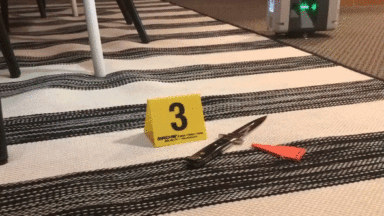
Field Work: Proper placement of placards into crime scenes. Beginner HDS series with Ken Jones.

1 2 3

© 2025 Leica Geosystems – Part of Hexagon | Privacy Policy | Code of Business Conduct and Ethics | Cookies Settings | Ethics | Compliance

Designed by WPZOOM