• Home
  • 3D Scanning
    • BLK360
    • BLK360 G1
    • BLK2GO
    • BLK2GO PULSE
    • BLK2FLY
    • BLKARC
    • RTC360
    • P-Series
    • Cyclone FIELD 360
    • Cyclone REGISTER 360 PLUS
    • CloudWorx
    • Cyclone 3DR
    • TruView
    • Map360
    • Archive
  • Mobile Mapping
    • Hardware
      • Pegasus Backpack
      • Pegasus Two Ultimate
    • Software
      • Inertial Explorer
      • Infinity
      • Pegasus Manager
        • Mission Planning
        • Processing
        • Rail Factory
        • Rail Track Geometry
        • Real Time Data Exchange
        • Road Factory
        • Trajectory Adjustment
        • View Only
      • Pegasus MDA
  • Virtual Training
SMART PLAN
Login Register
Table of Contents
Toggle sidebar & navigation
  • Home
  • 3D Scanning
    • BLK360
    • BLK360 G1
    • BLK2GO
    • BLK2GO PULSE
    • BLK2FLY
    • BLKARC
    • RTC360
    • P-Series
    • Cyclone FIELD 360
    • Cyclone REGISTER 360 PLUS
    • CloudWorx
    • Cyclone 3DR
    • TruView
    • Map360
    • Archive
  • Mobile Mapping
    • Hardware
      • Pegasus Backpack
      • Pegasus Two Ultimate
    • Software
      • Inertial Explorer
      • Infinity
      • Pegasus Manager
        • Mission Planning
        • Processing
        • Rail Factory
        • Rail Track Geometry
        • Real Time Data Exchange
        • Road Factory
        • Trajectory Adjustment
        • View Only
      • Pegasus MDA
  • Virtual Training
HDSU Smart Plan

Category / 3D Scanning

All Things 3D Scanning

Custom StationDetail ScansDistance to ObjectDual Axis CompensatorEDMField of ViewFilterFixed DistanceHDR ImagingImage CtrlP20P30P40P50Quick ScanResolutionScan & ImageScanner SetupSensitivityTarget AllTargetsTripodWhite Balance
3D Scanning, P-Series Scanners

Free Station Scanning with the P-Series (P30, P40 & P50)

3D Scanning, Cyclone REGISTER360

Projects & Storage in Cyclone REGISTER 360 PLUS

Learn how to manage projects in Cyclone REGISTER 360

3D Scanning, CloudWorx, Cyclone 3DR, Cyclone REGISTER360, Infinity, Map360, Mobile Mapping, New HDS User, Pegasus Manager, PSG, Software, TruView, Uncategorized

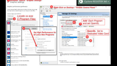
Graphics Settings Required for Leica Geosystems Programs

Required Graphics Setting that need to be set manually for all programs.

3D Scanning, P-Series Scanners

Viewing Data on a P-Series Scanner

3D Scanning, Archive

Copying Vertices from a Known Point in Cyclone Core

3D Scanning, Archive

Linking Databases in Cyclone Core

How to fix databases that are no loner visible in Cyclone Core?

3D Scanning, Archive

Using Batch Import in Cyclone Core

It it possible to setup a batch routine to import different sets of raw data at one time. Watch the following video to learn how to use the Batch Import in Cyclone Core.

Cyclone REGISTER360

Part 6 – Advanced UCS Tools in Cyclone REGISTER 360 PLUS

The Advanced UCS tools are accessed in the Setup or Bundle Cloud. Users can set the UCS by Pick, Plane or Corner. By Pick and Corner give users the option to enter in a specific reference point. Watch the following video by Brian Elbe to […]

3D Scanning, Cyclone REGISTER360

Part 5 – Using Basic UCS Tools in Cyclone REGISTER 360 PLUS

This video by Brian Elbe outlines the basic UCS Tool found in the SiteMap of the project. After importing the data, before setting the UCS, click the letter A on the keyboard to display the world UCS. It is located on the first scan setup. […]

3D Scanning, Cyclone REGISTER360

Part 4 – Extracting Targets and Registering Data to Control

This video by Brian Elbe covers extracting targets and registering the data to control. It also shows how to finalize a project, edit and publish the registration report and point cloud data.

1 2 3 4 … 15

© 2025 Leica Geosystems – Part of Hexagon | Privacy Policy | Code of Business Conduct and Ethics | Cookies Settings | Ethics | Compliance

Designed by WPZOOM