Cross Sections and Profiles in CloudWorx for AutoCAD
Learn about creating slices, profiles and fitting sections in CloudWorx for AutoCAD.
All Things 3D Scanning
Learn about creating slices, profiles and fitting sections in CloudWorx for AutoCAD.
Learn about what data formats are loadable in CloudWorx for AutoCAD.
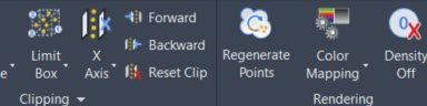
Learn about the Cloud Rendering tools inside CloudWorx for AutoCAD.

Historically many Leica Clients would only have a single Leica Geosystems myWorld account for the entire company. It is advised for each Leica user to have their own login credentials for myWorld. It offers your staff access to the resources associated with your Leica Geosystem […]
During this 20 minute Virtual Class Recording, Kriss Myer steps the user through the workflow of creating strappping tables for tanks in Cyclone 3DR. The class covers cleaning noise on the tank, meshing, setting a UCS and creating the strapping tables. Click the link below […]
During this 20 minute Virtual Class Recording, Kriss Myer steps the user through the workflow of calculating the volume of a tunnel in Cyclone 3DR. The class covers creating and editing the mesh, filling in holes and capping it to create a water tight mesh. […]
Multiple Download and Instructional Video Links for TruView Local – Legacy install, Pack&Go, JSV Videos, and TruView 2021 and TruView Portable
The following workflow videos shows how to manage multiple control files in a single project in REGISTER 360. It covers minimum requirements for targets, how to edit control files and create virtual targets.
Migrate USB Dongle to EID License for Map360.