Processing RTC360 Data – Section 2
In Section 2, RTC360 Review Key Tools in Desktop Software”, the RTC360 sample project has been imported. We will review the Leica Cyclone REGISTER 360 PLUS Toolbars, workflow tabs, and navigation tools.
In Section 2, RTC360 Review Key Tools in Desktop Software”, the RTC360 sample project has been imported. We will review the Leica Cyclone REGISTER 360 PLUS Toolbars, workflow tabs, and navigation tools.

Tips and Tricks for updating to Cyclone Register 360 Plus 2025.0.0 released March 27 2025. Three major releases were pushed out March 27 2025. In summary make sure: Uninstall all old programs, get your windows updates installed and update your dedicated graphics driver from NVidia’s […]
In this Cyclone 3DR workflow demonstration we will be performing a wall flatness and verticality analysis on a section of brick wall.

This post goes over how to import a control file into Cyclone and geo-reference the point cloud data.
This Quick Guide covers how to import BLK360 data into Cyclone and explains the different import options.
Volumes are easily calculated in the Cyclone software. The three different volume calculations available are Enclosed Modeled Objects, TIN to a Plane, and TIN to TIN.
The UCS tools are important for manipulating the point cloud. UCS can be Set to Up Direction, Set to an Object, Set from Points, Set to X, Y, Z Axes.

The Unify and Merge commands combine points into one cloud to improve performance of large point clouds. The point cloud may be decimated through the Unify command. Merge combines points but allows the individual clouds to be turned on and off.

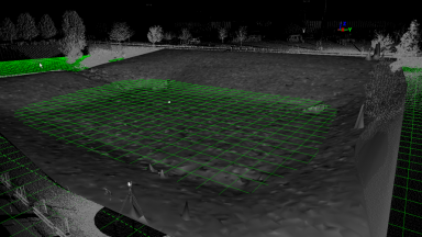
Existing TINs can be re-sampled to reduce the number of triangles and create an evenly spaced grid of points or mesh over an irregular mesh.
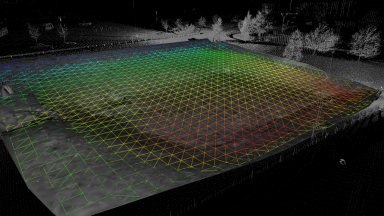
Surface deviation is a great tool to see how much one TIN deviates from another.